About

Welcome to the Wales Activity Mapping GIS web tool
This GIS web system is maintained by Pembrokeshire Coastal Forum on behalf of a partnership of organisations involved in the management of the coast and countryside across South West Wales. The partnership seeks to assist in the sustainable management of the area to the maximum benefit of all potential users by constructing a coherent picture of activity.
This website is designed primarily for those needing to consider recreation, conservation and tourism in decision making and is not aimed at promoting any activity or location.
Disclaimer
Data displayed on Wales Activity Mapping GIS viewing system will usually merit further interpretation in a spatial, temporal or other context and should not routinely be taken at face value. The four site specific reports alongside each activity data set is intended to support such further interpretation.
(Site Infrastructure / Activity Infrastructure / Location Management / Data Management)
Pembrokeshire Coastal Forum cannot be held responsible for any inaccuracies in data provided by organisations other than Pembrokeshire Coastal Forum. Datasets are not to be used for navigation. The information on the website does not constitute legal or professional advice or show legal practice for which the appropriate legislation should be directly referenced.
Quick tips
- Click, hold and drag with mouse to pan map.
- Click and release (without drag) to query a point on the map.
- Hold down shift key and drag a box with mouse to zoom to area.
- Use mouse wheel to zoom in and out.
- Click here for further help about the WAM web tool
Layers
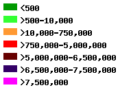
| Current 2019 data – view legend below for colour | |
| Historic 2008 data | 
|
| Both – click here for details of how to interpret the data | |
Untick all layers
Land based activities
| Beach Activities |  |  | |
| Caving Potholing |  |  | |
| Climbing |  | ||
| Coasteering |  | ||
| Cycling |  | ||
| Quad biking |  |  | |
| Horse riding |  |  | |
| Kite boarding |  |  | |
| Land yachting |  |  | |
| Power kites |  |  | |
| Shooting |  |  | |
| Walking |  | ||
| Wildlife watching |  | ||
| Dog walking |  | ||
| Angling (shore) |  |  |
Land based activities (2019)
| Bait digging |  |  | |
| Event hot spots |  |  | |
| Gathering living resources |  |  | |
| Drone flying |  |  | |
| Photographers |  |  | |
| Wild camping |  |  | |
| Light aircraft (power) |  |  | |
| Overnight camping |  |  | |
| Sunset watchers |  |  | |
| Light aircraft (nopower) |  |  |
Water based activities
| Body boarding |  |  | |
| Canoeing Kayaking |  | ||
| Kite surfing |  |  | |
| Snorkelling |  |  | |
| Surfing |  |  | |
| Swimming |  |  | |
| Windsurfing |  | ||
| SUP journeys |  |  |
Boat based activities
| Diving |  | ||
| Jet skiing PWC |  | ||
| Power boats |  | ||
| Cruiser sailing |  | ||
| Wake boarding, water skiing |  | ||
| Wildlife boat tours |  | ||
| Dinghy sailing |  |  | |
| Rowing |  |  | |
| Angling (boat) |  |
Other layers
| Public land |  | |||
| SW Wildlife Trust |  | |||
| Beach awards |  | |||
| Car parks |  | |||
| Dog ban areas |  |  | ||
| Lifeguarded beaches |  | |||
| Climbing Restrictions |  | |||
| Mooring areas |  |  | ||
| Slipways |  | |||
| PROW |      | |||
| Coasteering Feasibility |    | |||
| Valuation |  | |||
Conservation Layers
| SSSI |  | ||
| NNR |  | ||
| SPA |  | ||
| AONB |  | ||
| Country Parks |  | ||
| LNR |  | ||
| RAMSAR |  | ||
| SAC |  | ||
| Heritage Coast |  | ||
| MNR |  |
Marine Code
| Slow areas |  | ||
| Seal areas |  | ||
| Seal and Seabird areas |  | ||
| Seabird areas |  | ||
| Cetacean areas |  |
European Marine Site Plans and Projects
| Overview |  |  | |
| Abstraction |  |  | |
| Construction and operation |  |  | |
| Deposit |  |  | |
| Discharges |  |  | |
| Dredging |  |  | |
| Fisheries |  |  | |
| Navigation |  |  | |
| Other |  |  | |
| SSSI |  |  |
Filter
| Map confidence (1-5): | ||
| Data confidence (1-5): | ||
| Five year trend (1-5): | ||
| Useage scale: |
| EMS feature: |
Find
| You can search for a place or a postcode. | ||
| Use % as an unknown character in a placename | ||
| Search for: | ||
| Postcode: | ||
| Placename | ||